|
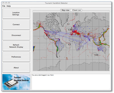
Main screen of the application
(click the image for an enlarged view). The displayed
active earthquakes (grey circles) refer to a simulated
P2P network, because currently the application is
still in beta testing.
The shown network consists of 5 subnets with their
respective supernodes and a large number of attached
nodes for sensing. |
The application is developed in Java, hence
it runs on any computing platform that supports
at least Java 1.6. Sensing of seismic activity
is very hardware related and is currently only
supported on Windows.
To the left you see the main window. The large
buttons on the left border allow to control the
application. When you start it the first time,
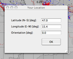
use the 'Location Settings' button
to make your geographical location known to the
network. A window will appear (see below), which
prompts you for your local latitude, longitude
and the orientation of your computer. These data
can be obtained from a GPS-mouse or from www.gpsvisualizer.com.
If you do not enter your coordinates, the software
will try to use your IP address to estimate your
location.
By pressing 'Connect' you will
be attached to the P2P network. If you become
a node or a supernode depends on the current network
topology and your preferences (see below). By
pressing 'Disconnect' you will
leave the P2P network again.
The main window displays the earth in Mercator
projection. Previous earthquakes are shown
as colored dots. The colour indicates the depth
of the earthqake focus:
red: 0-33 km
orange: 33-70 km
green: 70-300 km
blue: 300-700 km
|
 |
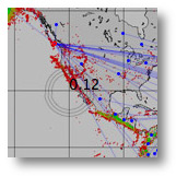
| Display of a currently
active earthquake near California, magnitude
0.12. |
|
Currently active earthquakes, which are sensed by the P2P network, are indicated
by animated grey circles (see left). The intensity
of the earthquake is displayed by a numeric value
in the epicenter. Strong undersea-earthquakes
can initiate a Tsunami. If the application detects
such an earthquake, it will display a window with
a warning message.
Network display::
The P2P network you are connected to is displayed
by blue wires as an overlay on the earth map.
The little blue dots indicate network nodes (which
perform sensing), while the larger red dots indicate
supernodes (which perform data analysis). Your
own location is indicated by an even larger red
dot. The current status of the network display
as well as the currently active earthquakes is
updated by pressing 'Refresh Network Display'.
The white area at the bottom of the window displays
status messages, for example the name of the supernode
you are attached to, as well as possible network
error messages. |
|

|
| Set your geographical location
and orientation of the computer in this window (click
image for an enlarged view). |
Location settings::
In the window to set your geographical location, you
also need to set the orientation of your computer. This
is necessary, because when your harddisk is used for
sensing, the sensors signal will depend on how your
harddisk is oriented with respect to the seismic wavefront
of the quake. By definition, an orientation of 0 deg
refers to a harddisk whose cables point in the northern
direction. The orientation is measured counter-clockwise. |
 |
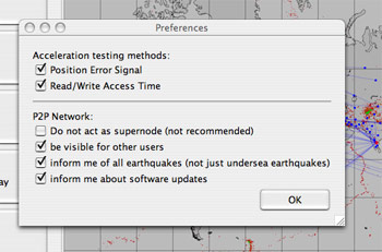
| Preferences window. |
Preferences:: In
the preferences window you can set the parameters for
acceleration sensing and for the P2P network.
Several strategies are used to estimate the acceleration
due to earthquakes. Two of them may impact your system
performance. These can be switched off selectively:
(i) analysis of the Position Error Signal and (ii) the
read/write access time. The first method is not possible
on all harddisks, because the manufacturers usually
keep the method to read this signal as a trade secret.
Also the quality of vibration sensing depends on your
components.
In the second section of the preferences window, the
parameters for the P2P network are set. You can force
the application not be become a supernode, hide yourself
from other users, get information only about undersea
earthquakes and be notified of new software releases.
|


